/
Source Image
Loading...
English
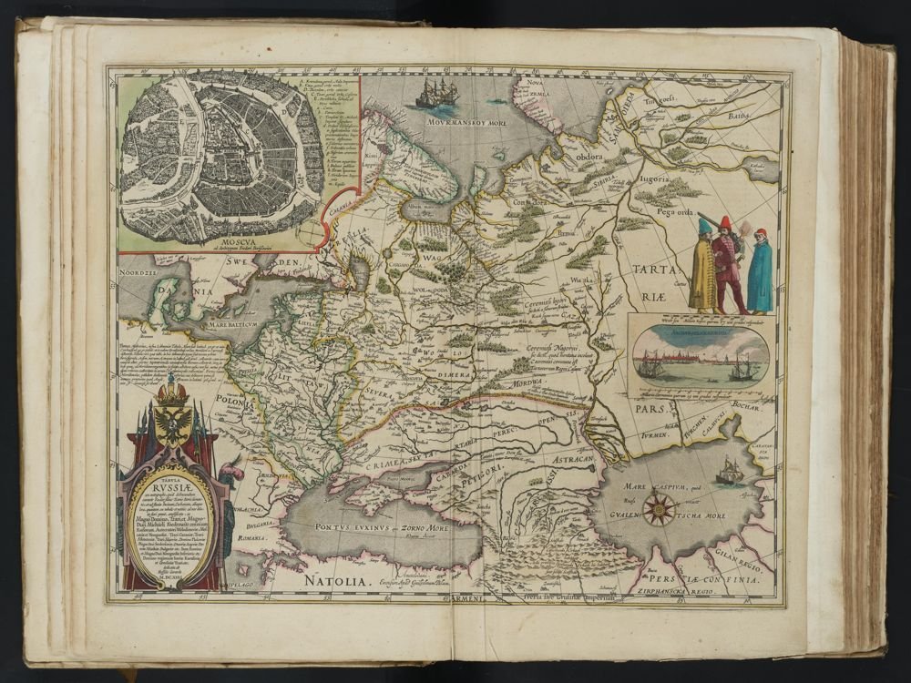
MAP OF RUSSIA
Dedicated by Hessel Gerritsz, 1614.
A detailed map of Russia featuring a circular plan of Moscow, an inset view of Arkhangelsk, and illustrations of traditional Russian dress. The map highlights river systems and regional boundaries.
MOSCOW
After the archetype of Fedor Borissowits
A. Kremlin, the Emperor's Palace.
B. Kitaia gorod Central city, the middle city.
C. Tsar gorod, the Imperial city.
D. Skoro-dum, the outer city.
E. Strelletska sloboda, that is, the Suburb of the Soldiers.
ARCHANGELSK
The Russians call this city or village, situated at the mouth of the Dvina, "Archangelsckagorod" because it is near the Monastery of the Archangel Michael.
DEDICATION
Dedicated to the Tsars Fedore Borisso-wits, and the Great Lord, Tsar, and Grand Duke Michael Foedorowits, Autocrat of all the Russias, Tsar of Kazan, Tsar of Astrakhan, Tsar of Siberia, Lord of Pskov, Grand Duke of Smolensk, Tver, Yugra, Perm, Vyatka, Bulgaria, etc. Also Lord and Grand Duke of Lower Novgorod, etc. Lord of the regions of Iberia, Karsalinia, and Georgia, Tsar.
North Sea, Denmark, Sweden, Lappia, Karelia, Livonia, Poland, Lithuania, Podolia, Volhynia, Severia, Crimea or Tartary, Mordwa, Petigori, Astrakhan, Siberia, Yugra, Obdora
Use ← → arrow keys to navigateSwipe left/right to navigate·Produced by SourceLibrary.org in Amsterdam, 2026